

Queenborough House, 19 Queen St, Sandy Bay, Tasmanian Archives, NS1013/1/1988
Researching a House History: A Tasmanian Example
Imogen Wegman
28 January 2025
There is something very appealing about finding out the story of a house. Whether it’s the construction of the physical structure, the lives of those who have passed through its doors, or the land on which it is built, there can be a magnetic force drawing us into uncovering the narrative of the specific space. Houses carry an emotional heft that turn a simple place of shelter, as Darryl Kerrigan would say, from a house to a home.
As a landscape historian and family history lecturer, I am often asked for help with navigating land and house records by people who are researching the history of a property. There are a lot of different places to start looking for the history of a house, depending on what the goal of the research is. Do you want to:
- Uncover some stories about the people who have lived there over time?
- Find out about the construction history of the house?
- Know about the land it was built on?
Or is your goal to find out anything you can?
Start by gathering the information you already know and organising it into a timeline. Identify the names of people and places, and the gaps in the details. These will help determine your approach, especially as you try to decide where to begin.
As part of the Everyday Heritage project, Chief Investigator Kate Bagnall asked me to research the history of a house built in Hobart by Royden Ah Chung, the son of Chinese migrants, in the early twentieth century. She knew approximately when the house had been built and sold, but the family records weren’t clear on when alterations had been made or exactly why. The questions we were trying to answer related largely to the physical structure, rather than the people living in the house, so I knew my priority would take me to building and land records.
Often the physical location and address are good places to begin: looking up the address in some different records or using spatial records like aerial photographs and maps to see what might have changed over time.
We knew that the house was built on recreational land that had been subdivided in the early twentieth century. Libraries and archives sometimes hold the plans for such subdivisions, so I searched for the name of the main road running through the area in the Tasmanian Archives and found a partially dated subdivision plan (Image 1). It had enough detail to lead me to an advertisement in The Mercury for 6 February 1915, and I could see that this address was one of 268 plots for sale.
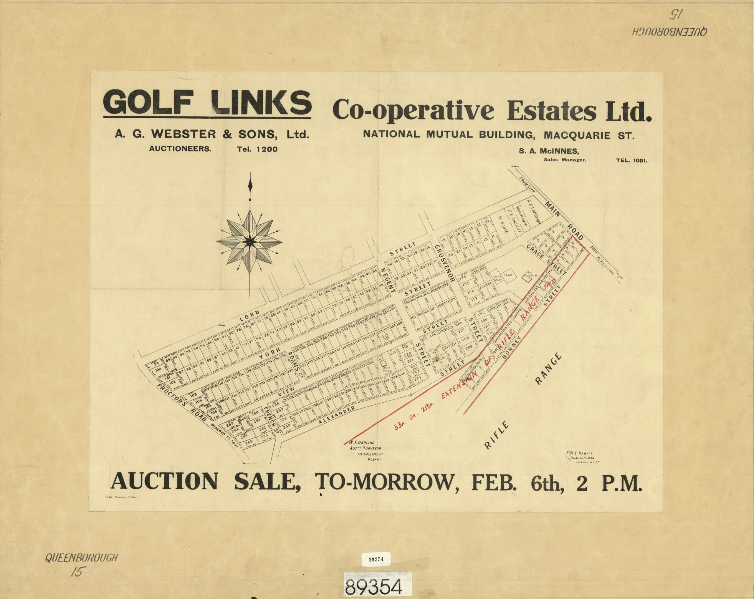
IMAGE 1: W.F. Darling, ‘Q/15: Golf Links auction sale tomorrow’, 6 February 1915, Tasmanian Archives, AF721/1/540
These records gave us a starting date to look for Royden Ah Chung’s purchase of the property. LandTasmania (the public-facing state government division overseeing natural resources and the environment) generously provides digitised copies of all their historic land titles records. The Ah Chung family were also known by ‘Chen’ and after some hunting through different indexes, I found the Certificate of Title (Image 2) which contained a great amount of information about the property’s history.
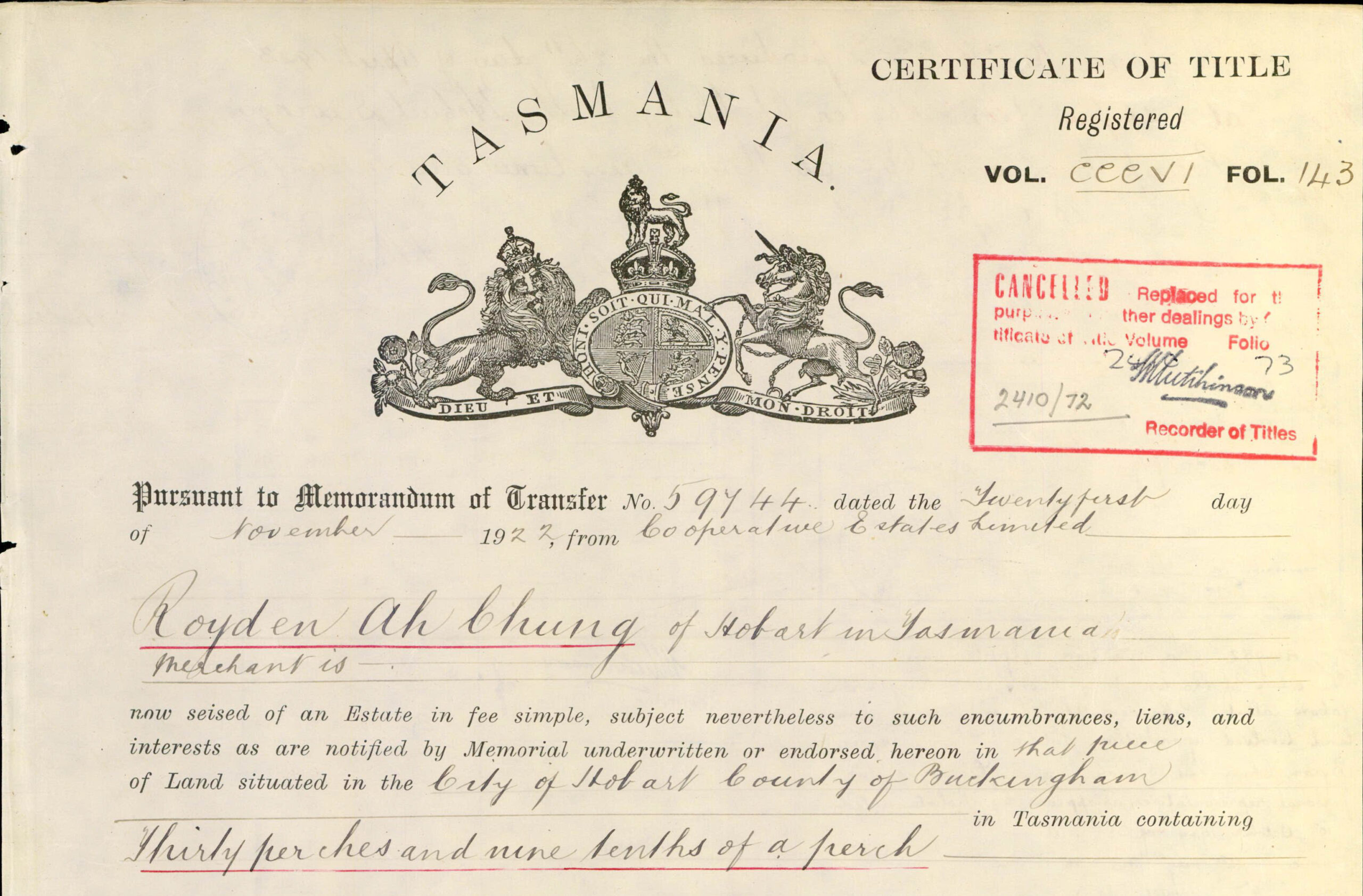
IMAGE 2: Certificate of Title, Cooperative Estates Limited to Royden Ah Chung, City of Hobart, Tasmania, 21 November 1922, 306/143, LandTasmania
The auction for the blocks of land must not have been a raging success – Royden bought his block in 1922 from the company responsible for the subdivision, and presented evidence he had acquired a mortgage of £850. A building plan, discussed in a moment, labelled blocks on either side of his as still vacant in 1925.
The certificate also tells us that the land went to Royden’s wife and two children on his death in 1949, and they sold it in 1953. It was then sold several times in quick succession – in 1964, 1966, and 1968 – before this record ends. This rapid set of sales raises questions about the use or condition of the building: why was a house in a popular Hobart suburb sold three times in a decade?
The physical appearance of the house shows that there have been some alterations over the years and the family’s photo album confirms this – a changing structure stands in the background of captured memories. Old windows have been bricked up and there are sections of brick where the colours don’t quite match, suggesting additions have been made over the years. Aerial photography shows that the house has a peculiar footprint, as though wings have been added on to a central block.
Now that we had a more complete timeline describing the purchasing history of the property, Kate and I went to the Tasmanian Archives to look for building files to better understand the renovations. Applications to construct or make alterations are filed with local councils then preserved. In Tasmania, many historic applications are found in the state archives, but there are some access and copying restrictions so we won’t share any images of them here. The earliest application shows that Royden wanted to build a shed in 1925, by which time his house was already constructed. In 1945, the family made extensive alterations, including the expansion of the lounge with a curved outer wall, and the construction of a second floor with more bedrooms to accommodate a family that had grown in size and wealth.
There is one more alteration proposal on file, this one dating after the Ah Chung family had sold the house, and it goes a long way to explaining why the house was sold so many times in the 1960s. In 1958, Mr G.R. Cumming filed plans to convert the house into flats, adding in a new external staircase and adapting some of the windows to better suit the purpose. After maintaining this investment property for several years, Cumming sold it in 1964. My suspicion is that it was never as profitable as its investors hoped, so no one held onto it for long in the 1960s.
The written record runs out after this as privacy laws restrict what information is available about property owners from the mid-century onwards, so we can only speculate what happened later in the century. An aerial photograph archive shows that the external staircase was present in the late 1980s (Image 3) but removed by 1994 (Image 4). Perhaps this indicates that the property was transformed back into a single dwelling. Or maybe an internal stair was built to provide access between the two flats instead.
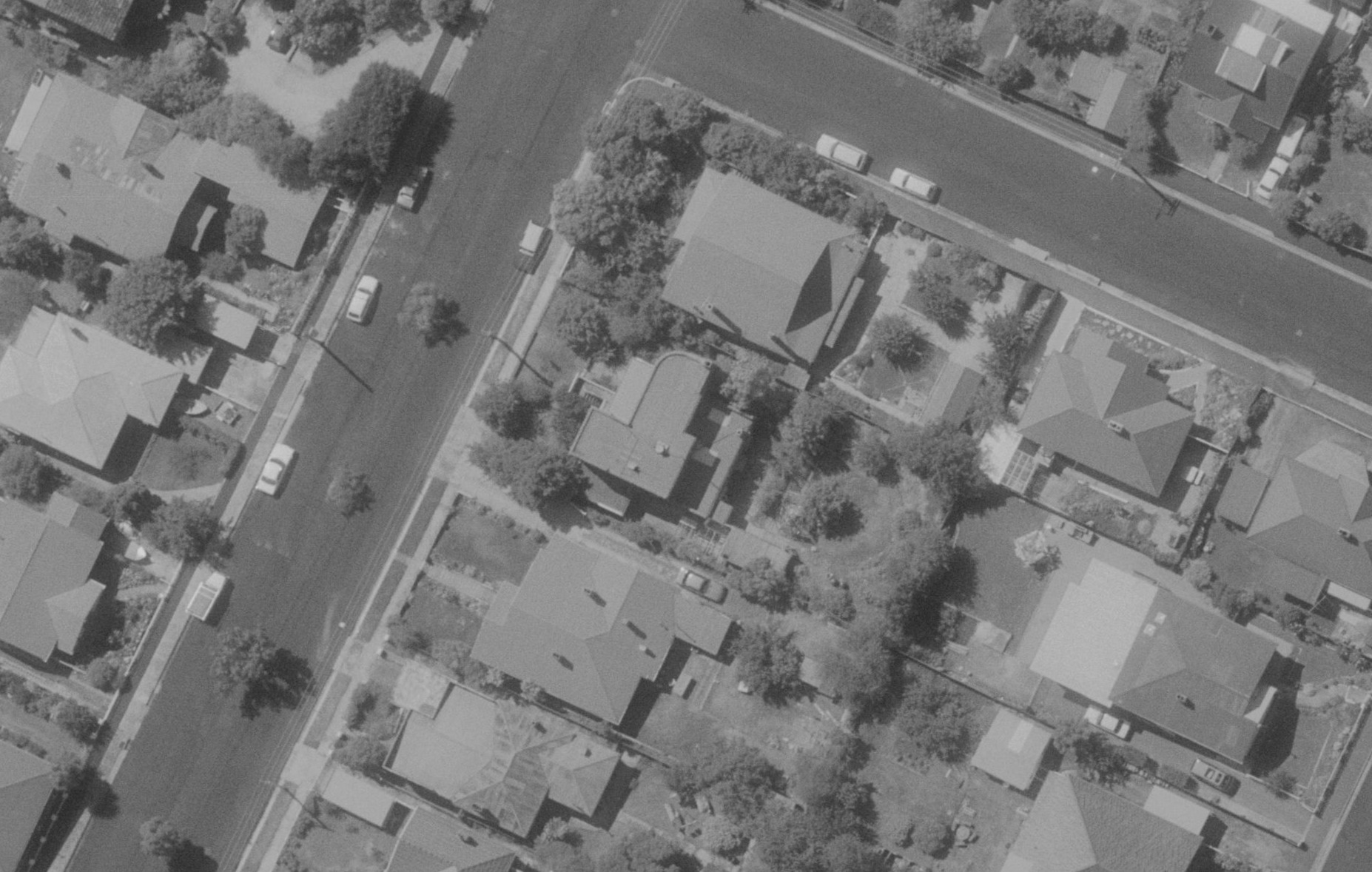
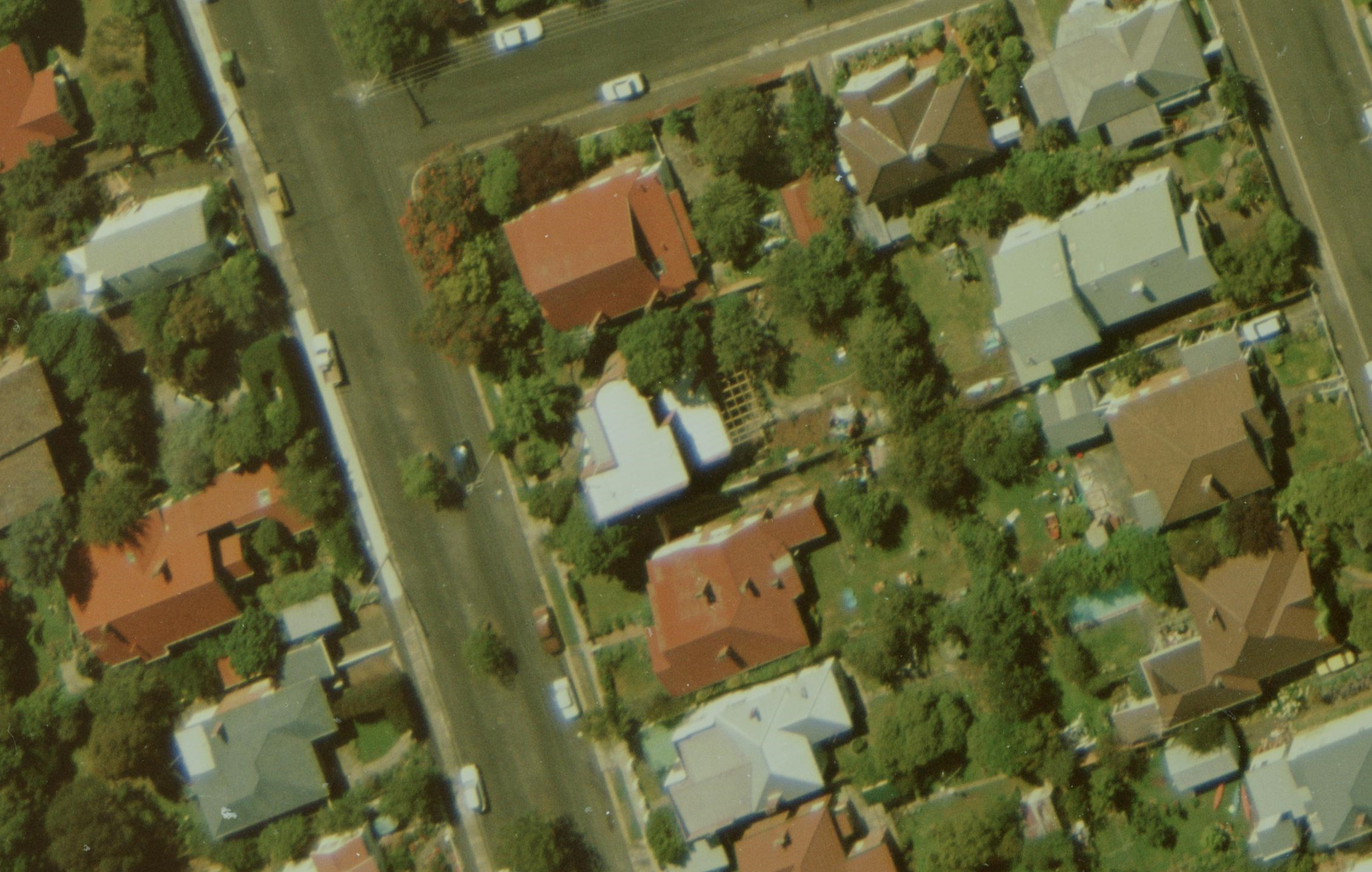
IMAGE 3 and 4: The house at the centre of these aerial photographs of Sandy Bay, showing the external stairs on 11 March 1984 (0995_051, black and white), but they’ve been removed by 12 February 1994 (1218_205, colour). Aerial Photo Viewer, LandTasmania
There isn’t a single way to approach researching the history of a house. While working through these files, I also searched for the address in Trove newspapers and got a glimpse into the lives of the Ah Chung family. In 1924 and 1925 someone at the property was selling off first a horse and cart, then a motorcycle and sidecar. A few years after both children were born, the family needed to advertise for general help. The same search revealed that there were several streets with the same name in Tasmania, so I needed to be careful as I perused the records. House numbers have often changed over time, as streets were formalised, subdivided, extended, or otherwise altered. When we research older houses, it’s important to account for such changes.
The 1925 application to build a shed noted that the blocks of land on either side of this were still vacant. To find out who first occupied these and when, I could have systematically searched through the Assessment or Valuation Rolls of the 1920s. These recorded details about owners and occupiers, and the development of the property. Post Office Directories are also useful for this, although they often only identify the occupier without noting whether they own or rent the property.
While talking to the family, Kate learned about life for the Ah Chungs living in this house, but they didn’t have a good record of the dramatic changes that had been made to the physical house. It started as an elegant but simple single storey family home, then expanded vertically with the construction of another floor to accommodate a growing family’s needs. It lived a second life as separated flats, with the stories of different people soaking into each floor. Now that we have built out this timeline, we have more research tangents to follow, to see what new narratives can be uncovered about this house.
Bio
Imogen Wegman is a historian at the University of Tasmania who researches the relationships between colonisers and the physical environments of colonisation. She has spent years working in a variety of public history settings and is known for getting too enthusiastic about historic maps.

Hi, I am trying to find the history of my address, 107 High Street Campbell Town. As it stands today, it has a 1930’s house and a 1950’s addition of a shop that is attached to the side of the house and is part of the same address. In the back yard sits an old structure approximately 3 meters x 7 meters with failing concrete walls (under 1 meter high) full of dirt, also has a stand pipe with what appears to be a water supply exposed at the structure that runs underground towards the residence. Is this a place I can find out more about and the significance of the structure? Thank You. Anthony Young
Hi Anthony, Richard has made some very helpful comments below – it could well relate to some kind of WW2-era industrial usage. I can’t see any helpful digitised maps of the area on Tas Archives, but if you go to the DPIPWE Aerial Photograph viewer (https://dpipwe-au.maps.arcgis.com/apps/webappviewer/index.html?id=01018d8cffe449ba8ac4c569a40bf5fb) and use the time slider at the bottom of the screen, you will see a grid move across the map – this shows the different photo routes that have flown over the state. Zoom into your area and click on your property, and a pop-up will appear showing the available photos from the data range you have selected. You can scroll through the available thumbnails with the arrows, or click “more details” to download high res copies. It’s possible that you will be able to see the transformation of your property over the years by going through them systematically this way – in the 1960s there is a really clear photo of the structure with a roof and what could be two small chimneys (or structural posts).
Otherwise I would suggest chatting to the Northern Midlands Council, or asking at your local history group – it may be recent enough that there is living memory of the structure.
Imogen
I can see that in 1972 it appears old conveyance of Desmond Upton to Desmond and Margaret Upton, and formed a cartage contractors business in name of D J & M M Upton.
Maybe this odd structure was a simple platform they could easily offload from a truck. Maybe it had a shed on it?
Might have to ask about. Council building records, if they exist, might have a plan showing something useful?
I see there’s an odd rectangle at rear of your property on aerial photo.
The 1940 to 50 aerials show what looks like a very light coloured structure, roof in same spot so that is way before 1972.
Hi Everyday Heritage team,
I have been trying to find the history of our home at 14 Parliament Street, Sandy Bay, Hobart without much success. A few snippets on the Tasmania Library Archives and Trove hasn’t provided much. Any thoughts or research would be very much appreciated. Many thanks.
Regards
Tony
Hi Tony, I don’t know what you have found already, but there are some occupant and owner names of 14 Parliament St available, which should give you some fresh leads. I’m going to throw some ideas at you to follow up!
In the Post Office Directories (https://glam-databases.net/tas-pod/-/search?q=14+parliament) we can see that there are several people living there in 1903 and 1904 – this deserves some investigation in itself to work out if it was a boarding house or if they were family – but more importantly, this provide us with some names to look up in the Valuation Rolls. Using the Index (http://nla.gov.au/nla.obj-1382450620) I can quickly(ish) get to the right page of the 1903 Valuation Roll (https://libraries.tas.gov.au/Digital/TGG/TGG-72-3-2-1 page 2221) where I look for any addresses at Parliament Street occupied by either “Boyes” or “Rush”. There on the first page is one occupied by Mrs P Rush and owned by Mrs E Alsopp. It’s worth checking the other pages to make sure this is the only match – it’s frustrating that they aren’t listed in order of address!
You can do this for all of the names in the Post Office Directory, and you’ll quickly see when the house was occupied by its owner or rented out from 1903 to the 1940s. Look at the other columns on the Valuation Roll too – they describe what’s on the property. 12 Parliament first appears in 1902 and 14 appears in 1903, so I’m guessing they were both constructed in 1902 with 12 finished and occupied just in time to be listed a little earlier. Number 14 is listed as a ‘cottage’ so it is possible that the Valuation Roll describes an earlier building on the site.
You can also see both on this map: https://libraries.tas.gov.au/Record/Archives/AF721-1-538 with a pencilled word that looks like the name “Balt” on 12, although I wonder if it is “built”. There is a gap in the occupation record in the Post Office directories in 1906-7, could this be when a cottage was replaced by a two storey brick house?
I hope that gives you some more names to look for in the Historic Land Titles. It can also be useful to look for the neighbouring names in Trove and other sources, you never know when your house was used as a landmark in a news story or legal case!
Imogen
The house in the image labelled Queenborough House 19 Queen St Sandy Bay NS1013/1/1988 is incorrect. This is not my ancestors home and the girls are not members of the Pretyman Family. This image features a different size and style of a home &
does not relate to my memories of visiting family at Queenborough House. This has been confirmed by relatives & neighbours (responding to as well as descriptions of Queenborough House I have in historical family documents. Some months ago I supplied information for correction/identification of my ancestors relating to my grandfather E R Pretyman’s digitised glass plate negatives @ TAHO. Awaiting these corrections to be made to endure accuracy of people & places in these images. See also comments on Tasmanian History Facebook entry by Brett Williams 18 Dec 2024.
Thanks for that information Christine. I’m really pleased that you have sent in a correction to the Archives – hopefully they’ll update their records!
Imogen